The 6 PM radar says it all..with a plume of moisture moving into our region from the Northwest.

Let me show you the latest forecasts for 24h total precipitation. For the 24-h period ending 4 AM Sunday, there is heavy precipitation along the western slopes of the Cascades (as much as 2-5 inches, black color), with an extension over Whidbey Is. and Port Townsend. I have never seen an extension of heavy rain away from the mountains like that.


And believe it or not, even more the next 24 hr under sustained northwesterly flow.


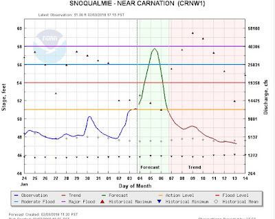
The NOAA/NWS River Forecast Center in Portland has revved up their warnings and is going for moderate flooding (blue dots) on several rivers draining the western slopes of the Cascades. Flood stage will occur on several more.

Many of the locations will get very close to a major flood, as illustrated by the river flow prediction for the Snoqualmie River near Carnation.
If you want to see something impressive go Snoqualmie Falls on Monday or Tuesday. In any case, you can choose to be entirely dry or completely drenched on Sunday....


