One important development: Janet Cole of the National Park Service visited the site yesterday. Bill Bacchus, chief scientist of Olympic National Park, sent me this map of the damage, based on Janet's survey of the scene, and the following narrative:
"Most of the trees appeared to be wind thrown, but as you can see from the photos, many were also broken near the base. The amount of trees down was inconsistent, in some areas, nearly every tree is down, but the majority of the area seemed to have lost about 40-60% of standing trees. ... I am attaching an image which shows Janet's rough estimate of the blow down area including arrows showing the direction of most blowdown. Near the drainage outlet, the trees seemed to have fallen southeast, while the western edge trees were oriented more north south. In the eastern edge, the trees were closer to east/west"

And below is a box of similar dimensions to what she drew....with the sides about 1/2 mile long. The prevalent wind direction was from the north-northwest with a tendency to splay out towards the lake.

Another interesting piece of evidence, in fact something quite unique in such weather detection work, is the seismic record at Quinault, something sent me me by Dr. John Vidale, who used to be WA State Seismologist. At 1:26 AM that morning there was a lot of activity...and no tremors were noted at other regional stations. Dr. Vidale suggests that it may represent the tremor produced by huge, falling trees. Fascinating. More evidence for the timing.
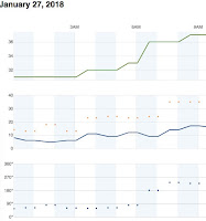
 Now lets examine local weather stations to see if there is any evidence of strong winds or a major weather transition at surface stations. Using the nice weatherunderground.com interface, we turn to the closest station on the south side of the lake, only a few miles away (KWAQUINA2, see map below). The station stopped recording at 2 AM.
No real change in temperature or dew point (top panel, right figure). Wind speeds were quite low (second panel, with blue being sustained winds, dots are gusts). Steady rainfall (blue line in third panel). And the pressure shows a weak downward trend (bottom panel). But look closely. VERY closely. There is a downward spike at 1:25 AM. Something abrupt and short-lived happened. Is this important, or is it a red herring provided by some meteorological Moriarity?


Another station on the map (NE corner), a highly accurate NOAA climatological site, only has temperature and dew point. Here is the plot from that station (MQTCW1). Nothing happening at the time..


Our meteorological Sherlock is perplexed. The trees fell to the south or southeast, implying a very strong northerly wind. None of the surface locations shows strong wind and most of them are easterly or southeasterly. Wrong direction. There is no strong convection or thunderstorms, so no microbursts.
But there had to be something going on around the time of the tree fall...and there was---a frontal zone was approaching, with warm air and southerly flow surging in aloft, while cooler easterly flow dominated near the surface.
The National Weather Service official surface analysis for 1 AM shows the front approaching, and it was associated with a low pressure system that would bring strong winds to western Washington later in the morning.

Could this be important? We get fronts all the time without extreme local blowdowns as occurred on January 27. Sherlock is unsure.
We will investigate this last lead in the next installment.
 _______________________________
Announcement: A very interesting free lecture open to the public
The history of cloud seeding to enhance precipitation, and prospects for the future. Professor Bart Geerts, University of Wyoming

And below is a box of similar dimensions to what she drew....with the sides about 1/2 mile long. The prevalent wind direction was from the north-northwest with a tendency to splay out towards the lake.

No real change in temperature or dew point (top panel, right figure). Wind speeds were quite low (second panel, with blue being sustained winds, dots are gusts). Steady rainfall (blue line in third panel). And the pressure shows a weak downward trend (bottom panel). But look closely. VERY closely. There is a downward spike at 1:25 AM. Something abrupt and short-lived happened. Is this important, or is it a red herring provided by some meteorological Moriarity?
Another station on the map (NE corner), a highly accurate NOAA climatological site, only has temperature and dew point. Here is the plot from that station (MQTCW1). Nothing happening at the time..
Frustrating....perhaps the Sasquatch or alien visitation explanations should be taken seriously! OK, let's move out a bit.
The station in the terrain to the SE showed nothing interesting, with moderate easterly flow during the period. Wrong direction
And the station to the west-southwest was similarly bland, with southeasterly winds:
Our meteorological Sherlock is perplexed. The trees fell to the south or southeast, implying a very strong northerly wind. None of the surface locations shows strong wind and most of them are easterly or southeasterly. Wrong direction. There is no strong convection or thunderstorms, so no microbursts.
But there had to be something going on around the time of the tree fall...and there was---a frontal zone was approaching, with warm air and southerly flow surging in aloft, while cooler easterly flow dominated near the surface.
The National Weather Service official surface analysis for 1 AM shows the front approaching, and it was associated with a low pressure system that would bring strong winds to western Washington later in the morning.
Could this be important? We get fronts all the time without extreme local blowdowns as occurred on January 27. Sherlock is unsure.
We will investigate this last lead in the next installment.

Announcement: A very interesting free lecture open to the public
The history of cloud seeding to enhance precipitation, and prospects for the future. Professor Bart Geerts, University of Wyoming
February 15th, Kane Hall, University of Washington Campus
For information and to register go here:


