But fair-minded folks then ask...are there any signs that anthropogenic global warming is occurring? The answer is yes, and I have tried to cover them in some previous blogs.

Today I will talk of another one: the dramatic reduction in very cold days here in the Pacific Northwest. Days in which Arctic or modified Arctic air moves into the region, bringing temperatures down to 20F and below near sea level in areas of the western Washington.
Let me illustrate by showing you the monthly averaged minimum temperatures averaged over the entire State (Washington, of course) from 1900 to today, using the data from the NOAA/NWS Climate Division data set (see below).
The minimum temperatures during the summer (around 50F) have risen very slowly and steadily during the past 118 years. But the lowest monthly temperatures, which of course occur mid-winter, are a different story. Huge differences in time, with much lower monthly minima during the first part of the 20th century compared to recent decades.
Specifically, during the past 25 years, the monthly minima never have gotten below 25F. Such cold temperatures were common before 1990, with the period before1955 including several months below 20F.

And this pattern is also true over the Puget Sound lowlands (below)

and over the Columbia Basin

We simply don't get the severe cold waves anymore, but why? Time for Northwest cold wave 101 and be prepared to be surprised!
As illustrated in the map below, our super cold waves occur when air from the Arctic moves down into the NW Territories, NW Alberta, across a lower area of the Rockies into the basin of the BC interior, and then through the Fraser and Okanogan Valleys into Washington (and if deep enough across the terrain).

Normally, air reaching Washington comes off the mild Pacific Ocean and thus we don't get cold. Only when the circulation changes so that we are cut off from the Pacific Ocean and air is pushed southward and across the Rockies and Cascades can the Arctic come to Washington.
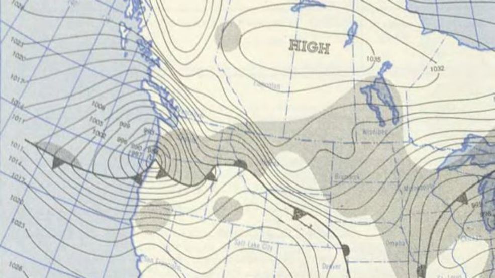
What atmospheric pattern does this? At the surface, this situation is associated with a cold high pressure area to our north and low pressure just south of Puget Sound--like the case (Nov. 1985) shown below

Another example is shown below, from a day during a supercold stretch in January 1950.
Aloft (e.g., 500 hPa, about 18,000 ft), the classic pattern is a big ridge of high pressure over the eastern Pacific that stretches into Alaska and a sharp trough over the Northwest (see below).

Now that you are trained up on Arctic outbreaks, why would anthropogenic (human-caused) global warming result in fewer strong Arctic outbreaks in Washington?
The first reason is our Arctic connection. Increasing greenhouse gases preferentially warm the Arctic, something shown by virtually all climate models. And the warming during the past century parallels this pattern, as shown by the observed temperature change since 1900 (below).

So clearly, if greenhouse gases warm the Arctic, our primo cold waves will be weakened since the Arctic is the source of the cold air.
But there is something else: the high pressure north of us has not been as extreme (high) during the past several decades and thus is less likely to cause cold air to push into our region. This is illustrated by a plot of monthly low level (1000 hPa) geopotential height (like sea level pressure) over British Columbia since 1920 (I blocked out the earlier period when there was much less data and thus less reliable). During the last 30 years B.C. has not gotten above 200, but that happened all the time during earlier decades.

There are two factors contributing to the weakened high pressure extremes. First, cold air is more dense and tends to cause higher pressure. But there is something else: global climate models suggest that the amplitude of large scale weather features will tend to lessen under global warming. So highs and lows will become weaker in the midlatitudes as the earth warms. I have done some of this analysis myself with past doctoral student Matt Brewer and this finding is quite robust.
So human-caused global warming is bad for business for cold waves. A figure from the National Climate Assessment based on observations shows this, displaying the change in coldest temperatures between a contemporary period (1986-2016) and the first 60 years of the 20th century (below). Washington State has some of the biggest decline in cold waves. Why? Because of our Arctic connection. Same with the upper plains of the U.S.

Thus, it drives me crazy when some global warming activists, such as Al Gore and ex-presidential science advisor John Holdren, claimed that human caused global warming was increasing cold waves in the U.S. or making cold waves more frequent. Poor science and in contradiction to observations.
Why do they purposely deceive the public? Because they were afraid that some recent (moderate) cold waves might give support to "deniers" and skeptics who "believe" that global warming is nonsense.
Who in the world would do that?

My take is that scientists and those concerned about the environment should stick to the truth and the best science. Telling tall tales to neutralize the "fake news" of the other side, will not advance science nor help society deal with environmental problems. Everyone loses.


