In fact, the minimum temperatures at locations around the region were warm with upper 50s at several locations, with some stations only dropping to the mid-60s. Sea-Tac Airport had their record high low temperature for the date (58F). In fact, it was the highest low for any date during the first half of May.
What was the reason for this morning warmth? Well, we started out with near record warm air aloft for the date because of a ridge of high pressure overhead. To show this, here are the climatological temperatures in the lower atmosphere (925 hPa pressure, about 3000 ft) at Quillayute, on the WA coast, with today's observation at 5 AM shown by the silver circle. The red line shows the record for each date. The temps aloft were near record levels.
But warm temperatures aloft are not enough since infrared cooling to space from the surface will cause low-level temperatures to fall, working against any record.
But there was another factor that worked against this nighttime cooling: lots of water vapor in the lower atmosphere. A good measure of water vapor content is the dew point temperature, with higher dew points indicating more water vapor. So here is the climatology of surface dew point at Quillayute, with the circle indicating today's values--quite high...nearly at record levels.
Water vapor is a very active absorber and emitter in the infrared and helps to keep the temperatures up at night. That is why very dry deserts often get chilly at night even when the temperatures are extremely warm during the day. So with lots of water vapor, the normal nighttime cooling was lessened.
One factor that helped with keeping the moisture high was the lack of offshore-directed, easterly winds. Nothing dries out the air like strong downslope, easterly flow. Only when downslope, easterly flow is very, very strong can it produce record high temperatures.
One more thing....this has been an extraordinarily dry May so far. Seattle has only received .08 inches as of today...and we are halfway through the month. The rest of the month looks fairly dry, with the weather.com forecast through May 28th never showing more than a 20% probability of rain for any day. The driest May on record at Sea-Tac only received .12 inches. So perhaps we have a chance to beat the record.
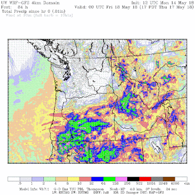
Ironically, the morning high resolution WRF model simulation showed the greatest rain action over northern CA and southern Oregon, which is unusual this time of the year. Good for topping off the reservoirs in northern CA.


